Smartphone measurements provide high-resolution earthquake maps
Sensors in smartphones already support early earthquake warning. Now the measurements can also be used to precisely map tremors in urban regions. This helps with rescue operations.
The fact that practically everyone has a smartphone in their pocket today proves to be extremely useful in earthquake situations. Small acceleration sensors, which are actually installed in thousands of devices for interactive gaming or position detection, can record the vibrations during an earthquake and send the signals to a central server. Within seconds, the server then sends warnings to people in the neighbourhood, giving them valuable time to get to safety. In some cases, the warnings are received half a minute before the earth shakes beneath their feet.
Whether this measurement data can also be used to map tremors within an affected area beyond the mere warning, however, remains to be seen. However, this information is particularly important in urban earthquake regions in order to know early on which neighbourhoods or buildings are particularly affected by the tremors.
In contrast to professional seismic instruments, the smartphones are not fixed to the ground. They are located on different floors of a building, are held in the hand or not, and their sensors are not calibrated against a reference value. In addition to the floor vibrations, the measurement data therefore also includes the specific characteristics of the device and the building in which it is located. A single smartphone measurement is too noisy to draw conclusions about the real ground vibration on site.
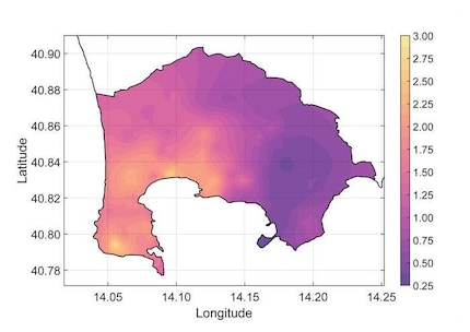
With the help of a statistical model, researchers from the University of Bergamo, the GFZ Helmholtz Centre for Geosciences and the European-Mediterranean Seismological Centre in France have now succeeded in removing these disturbing effects from the measurement data. The result is high-resolution earthquake maps for an urban region. The level of detail of these maps goes far beyond what seismic measuring stations alone could have provided.
The research team used the Phlegraean Fields near Italy, a densely populated and volcanically and seismically active region close to Naples, as a test region. During the test period between April and June 2024, the earth shook there several times - and 7,000 to 9,000 participating inhabitants in the 130 square kilometre «red zone» always recorded the activity with their smartphones. In contrast, there were just 29 traditional seismic stations in the same region, but their locations only covered part of the region.

Source: © CC BY-NC-ND 4.0, Finazzi et al. (2025)
The researchers used the map to recognise how an earthquake has different effects depending on the location. For example, the ground beneath the east of the zone actually dampened the tremors - this is reflected in the so-called amplification factor, which was between 0.25 and 0.5 there - while the same quake ten kilometres to the southwest was amplified by a factor of 2 to 3. With the help of such maps, those responsible for future quakes can estimate damage at an early stage and decide how to organise rescue teams and emergency measures within an earthquake zone.
Spectrum of Science
We are partners of Spektrum der Wissenschaft and want to make well-founded information more accessible to you. Follow Spektrum der Wissenschaft if you like the articles.
Original article on Spektrum.de
Experts from science and research report on the latest findings in their fields – competent, authentic and comprehensible.
From the latest iPhone to the return of 80s fashion. The editorial team will help you make sense of it all.
Show all