ETH measures snow depth from space
ETH Zurich has developed a method with which it can determine extremely precisely where, when, how long and how much snow there is. This is not only important for the weather forecast - avalanche research and hydroelectric power plants also benefit from it.
Where will it snow? And how much? With the help of artificial intelligence (AI), the researchers at ETH can use satellite images to forecast the snow line and determine the snow depth. The results are much more up-to-date and precise than those from other measurements.
Snow data from space
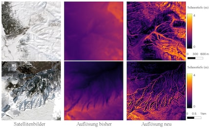
There are currently around 400 stations in Switzerland that measure the amount and height of snow using aerial photographs. This is a relatively small number and the resolution of the data is coarse: an area of 250 x 250 metres corresponds to one pixel in the measurement image. According to ETH, it is therefore difficult to make precise statements about snow conditions. These often vary within a few metres.

Source: ETHZ.ch
In the new technology, an AI is fed with satellite images from the European Space Agency (ESA). Its Sentinel-2 satellites record every location on Earth every five days. These images have a resolution of 10x10 metres per pixel and are currently the most detailed images that are freely available. The AI uses them to recognise where there is snow
In addition, the algorithm receives data on the respective terrain - geographical location, duration and frequency of solar radiation, degree of inclination and so on. By combining images and spatial data, the AI can forecast snow depths at any point - even where no measurements can be taken. The change in the snow line can also be predicted on a weekly basis.
The researchers tested the AI during two winter seasons. They compared the forecasts with manual measurements. Based on the results, they adapted the system so that incorrect predictions were less likely to be off the mark and became less frequent. This method is called "supervised learning".
What to do with this data
In addition to a precise snow report, the model opens up new opportunities for winter tourism. Measures for the pistes can be planned based on the snow line. Those responsible can also forecast how large the influx of visitors could be. The data also helps to assess the risk of avalanches and is important for operators of hydroelectric power plants.
The system will also be used outside of Switzerland - for example on the American continent or in the Himalayas.
Cover image: ShutterstockI've been tinkering with digital networks ever since I found out how to activate both telephone channels on the ISDN card for greater bandwidth. As for the analogue variety, I've been doing that since I learned to talk. Though Winterthur is my adoptive home city, my heart still bleeds red and blue.